For the first time since the early-2000s, much of the vegetation along the banks of the Pretty River dike will be cleared out, but at least one Collingwood councillor is hoping it can remain.
The Nottawasaga Valley Conservation Authority (NVCA) has partnered with the Town of Collingwood to take on some heavy maintenance work along the two-kilometre dike that runs through town. That will mean cutting out small material from the understory (vines, large shrubs, small trees, invasive species) for the first phase, and taking out select trees during the second phase.
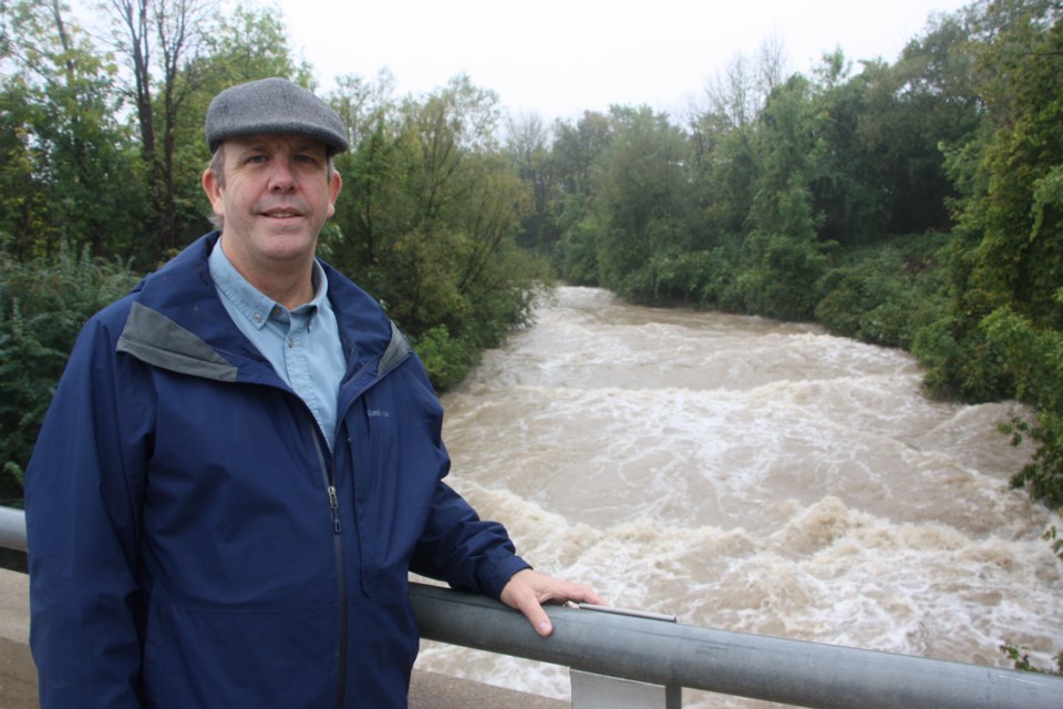
Mark Hartley, senior engineer with the NVCA, explained the dense vegetation works against the role of the dike to take high volumes of water through town and into the bay. This week, during one of the more significant rainfall events of the last five years and the biggest rainfall of this year, the Pretty River was rushing through the middle of the dike, but water was caught and nearly standing still among the vegetation at the sides of the dike and on the bank.
This dynamic decreases the volume of water moving through the dike and can lead water levels to rise higher, increasing the potential for water to spill over the dike and flood nearby homes, roads, and buildings.
“That’s why we need to get in there and give it the maintenance it needs to function as flood conveyance infrastructure,” said Hartley. “There’s not much you can do when the event is happening. Conservation authority work is all about preparedness.”
The Pretty River dike was built in the 1970s to reduce the flooding risk in Collingwood’s urban areas. The two-kilometre dike was built with steep banks lined with 12- to 18-inch stone to prevent erosion. Much of the bottom of the dike is bedrock.
The watercourse takes water from storms and tributaries from the area of Poplar Sideroad through the east end of Collingwood and out into Georgian Bay.
When NVCA staff came to explain the upcoming maintenance work to Collingwood council on Sept. 20, Councillor Yvonne Hamlin expressed her concern about removing trees and vegetation along what she called one of Collingwood’s most beautiful trails.
There is a walking trail along one side of the dike separating the Pretty River from residential homes behind the dike wall.
There’s also a popular swimming spot in the dike between Hume St. and Pretty River Parkway.
She suggested the approach should incorporate more “naturalization,” indicating the 1970s design was more like the concrete structures used for the Don River in Toronto.
Hartley told CollingwoodToday this week he’s not surprised the maintenance work is getting some opposition, because people can be upset about the loss of vegetation and, particularly, trees.
“It’s good to have checks and balances, someone to say ‘are you sure?’ It keeps us honest,” said Hartley. “We’re trying to find the optimum solution between moving the water, but also creating habitat … we recognize the value of vegetation and the natural approach.”
The challenge in the case of Pretty River is space. There is residential and/or commercial development on both sides of the dike, limiting the room for the water to flow and adding more need for protection from flooding.
“A more natural approach would be that we have more space to work with,” said Hartley. “Folks in the Netherlands use the phrase ‘room for the river.’ Which is great if you have room, but sometimes we can’t.”
The 1970s design of the dike has “gone out of favour,” according to Hartley, but there are times when the challenge to protect homes in the space leftover leaves you “stuck.”
Both Hartley and Doug Hevenor, CAO for the NVCA, confirmed the maintenance on the river banks is not going to be clear-cutting, and some vegetation will be left, leaving green space and some shade for fish habitat. The banks of the river will not look like the “moonscape” they did in the 1970s, and will be mostly green with grasses and native plants covering the stone, according to Hevenor and Hartley.
“This is a rock system on natural land,” said Hevenor during the Sept. 20 council meeting. “We’re removing 70 per cent of species that have egressed to become challenging for the landscape. We’ve got grapevine and Virginia creeper girdling and strangling trees, so those [vines] will be pulled down.”
He said the maintenance to remove invasive plants will leave the landscape more conducive to pollinator understory.
Some trees will be removed, but Hevenor and Hartley said many of the existing trees on the bank are ash trees that have been infested with Emerald Ash Borer and will die. Dead and dying trees add hazards by blocking river flow and they could injure people who are swimming, fishing, or hiking in the area.
“This is a unique feature within your town and we want to support it the best we can, but we want to provide safety for flooding and tree fall,” said Hevenor. “We will be removing that understory canopy and doing a really strong sweep along both banks and then we would be able to make a real calculated inventory of how many tres would have to come out of that basin.”
Flood modelling of the area does suggest many trees will have to be removed, according to the NVCA. But trees growing outside the dike will remain, and the pedestrian trail will also stay put.
The first phase of work is slated to begin this fall, with the second phase occuring in 2022, but not between April and July when birds are nesting.
Gathering the data
The NVCA works with Environment Canada to monitor water levels over time, and to measure the flow rate of various watercourses.
Environment Canada crews were at the Pretty River off Raglan Street on Thursday morning to manually measure the river’s flow.
The peak flow on Pretty River Sept. 23 was 35 cubic metres per second, which is the second-highest flow rate on the river since 2006 when the monitoring station started recording water levels.
The highest flow recorded since 2006 was 41 cubic metres per second, which was measured in March, 2016.
You can follow the data collected by Environment Canada from the Pretty River online in real time here.
The NVCA does run a flood forecasting system and posts warnings and messages on its website here.
Flood mapping
Part of the role of the NVCA is flood mapping and warning for the watershed.
The Pretty River dike design and capacity was based on what is referred to as a regulatory storm event, which is an extreme storm that has about a one per cent chance of occurring in a given year.
In Ontario, two storms are used as “regulatory events,” Hurricane Hazel and the Timmins storm of ‘61. Flood mapping and modelling for Collingwood is done using the Timmins event.
The Timmins storm was a flash flood that took place Aug. 31, 1961, in Timmins. There was a torrential downpour that lasted just a few hours, but destroyed roads, homes, building foundations and personal property. A mother and her four children drowned in a home by the bank of Town Creek, where the flooding originated.
Under similar circumstances in Collingwood’s Pretty River from Poplar Sideroad to the Bay, floodwaters would rise from the river and onto the banks from 50 to 500 metres from the river depending on the severity of the storm. A 2018 NVCA report predicted there would be many buildings and residential homes in peril in the case of a major rain event.
“The hospital, as well as the paramedic station and the police station, would have limited access due to flooded roads,” states the report.
It further indicates major roadways such as Highway 26, Pretty River Parkway, Huron Street and First Street would be flooded causing loss of access and egress to the area.
Hartley said one of the challenges for governments and conservation authorities is planning for rare events, and having infrastructure in place to mitigate an extreme storm that may only have a one- to five-per-cent chance of occurring.
“It’s such a hard thing to imagine, so it’s a tough message to get across,” said Hartley.
According to the engineer and technologist predictions, even a more common event like a 2-year or 10-year flood would have a significant impact on major roadways in Collingwood along Batteaux Creek and Pretty River.
During this week’s storm, the flow rate in the Pretty River dike reached its second-highest speed recorded since 2006, and the highest since 2016.
“When events like this become more frequent, it’s all about trying to protect the town,” said Hartley.
Historically, Collingwood has had some dramatic flood events. Collingwood Museum has a collection of photos showing streets underwater and residents rafting along the floodwaters on debris during the 1912 Victoria Day flood and 1942 St. Patrick’s Day flood.
During those two events, the photos show flooding around what is now Collingwood’s downtown, including Hume Street, Market Lane, Second and Birch Street, and Minnesota Street.

