Collingwood is taking a closer look at its stormwater management system, turning its attention to the weakest links in the chain.
During Monday’s development and operations services standing committee meeting, councillors got their first look at the Master Stormwater Management Model report, the first of a two-phase process to identify stormwater infrastructure improvements within the municipality.
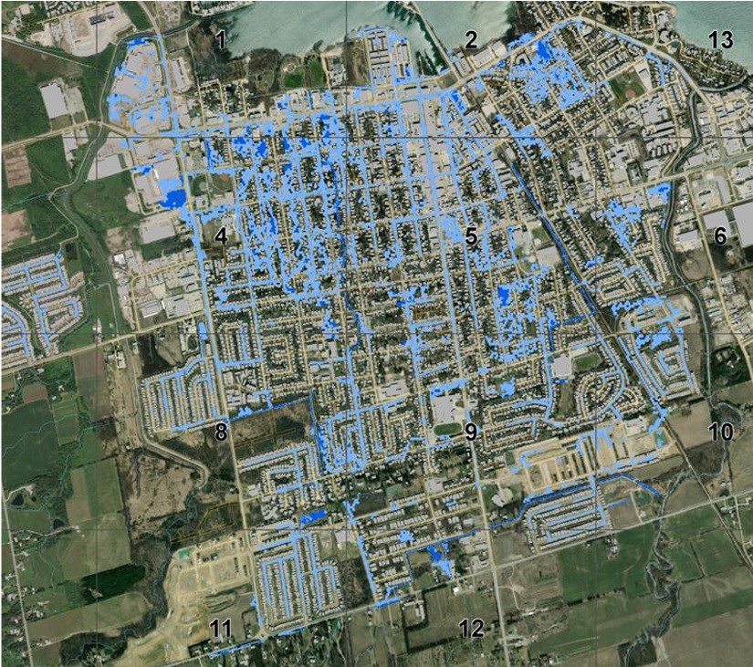
The report outlines varying worst-case scenario storm situations and how the existing town infrastructure would handle them. The information will be used to identify which areas of Collingwood most immediately need work done to mitigate flood risks.
CAO Sonya Skinner said it is unique for a municipality to have a report that marries stormwater trends with river flows.
“Not all municipalities have this type of information and I think it’s a big step forward for Collingwood,” said Skinner.
Greenland International Consulting Ltd. (Greenland) was retained in 2019 to complete the report and presented it to the committee this week.
To compile the report, Greenland and the town undertook background reviews of existing records and reports regarding the town’s infrastructure, stormwater reports, sub-watershed studies, and development records. Asset inventories of known stormwater ponds, storm sewers, catch basins, and outfalls were also provided in digital form to assist in creation of the model.
The extreme storm scenarios contemplated in the report are unlikely events to occur in any given year.
Under the mapping, a 100-year storm event was contemplated. Also contemplated was a major regional storm event. Within the Nottawasaga Valley Conservation Authority watershed, this is based on a significant rainfall event that occurred on August 31, 1961 where approximately 193 millimetres of rain was recorded in the City of Timmins within a 12-hour period. Anticipated impacts from climate change have been accounted for within the modelling parameters.
Should a 100-year event occur in Collingwood, under the mapping, the Pretty River would spill near Poplar Sideroad and the Rail Trail near Collins Street and flow north through a large section of downtown Collingwood. However, with possible grading revisions and maintenance of the Pretty River vegetation within the channel (which is currently ongoing through the NVCA’s maintenance program), the flood spill could potentially be eliminated.
In the Black Ash Creek, spill flows are anticipated to flow easterly along the Sixth Street ditch and through Black Ash Creek.
The Silver Creek and Townline Creek floodplains systems have several areas near Forest Drive and Silver Creek Drive that may be impacted during large events. Silver Creek would also flow over the Georgian Trail.
The report also contains 2D modelling of the urban parts of the municipality to show the flood-inundated areas during a possible 100-year storm event.
According to the modelling, the areas of town that would most be affected are the older tree streets (Spruce to Pine, First Street to Sixth Street).
Of note are areas around the Oak Street Canal, the area around Simcoe Street and Niagara Street, and the area between Robinson Street and Alice Street.
“The scenarios... are generally quite unlikely to occur in any given year, however they do happen,” said the town’s manager of engineering John Velick. “Staff just want to plan ahead and anticipate these scenarios.”
Coun. Deb Doherty asked the consultants if, based on the report, there were any areas of town that should be of immediate concern.
“We have a number of areas of town where historically, there is flooding,” said Velick. “A lot of it is in the west end of town. The Silver Creek/Townline Creek area floods. The Grey Sauble Conservation Authority is beginning a project with the NVCA to look at that area more closely.”
Velick noted the Cranberry Trail/Highway 26 area is also problematic, and the town is looking at that area as a capital project in 2022.
“Our storm sewer system generally responds quite well. We haven’t had a 100-year storm in the time I’ve been here, thank goodness,” he said.
Velick noted the next steps include the town identifying priority projects to address deficiencies projected by the modelling. He said this will start in 2022 through a municipal class environmental assessment master planning process. The estimated cost of this next step – $225,000 – was included in the 2022 operating budget.
“I think, until we acknowledge there’s a problem and see exactly what it is, we can’t possibly move forward to fix it,” said Coun. Yvonne Hamlin. “This is the first step.”
The committee voted unanimously to receive the report. The decision will need to be ratified at the next meeting of regular council on Feb. 28.

