The following is the first column of a series by Annette Sandberg.
Annette Sandberg grew up on the Blue Mountains section of the Niagara Escarpment, just three km west of Scenic Caves and she now resides in Collingwood. She is a local historian, researcher, and writer for the Gaslight Tour and the Grey Roots Museum, and guides people on interactive hikes through the land she writes about.
***********************
Have you ever thought of walking through the land of Merlin where magic comes alive with every step you take?
A place where, as you walk through the forests, the stories of the people who once lived there come alive through ruins, old farm machinery and cars left behind long ago, and the only limitation of travelling back in time is your own imagination.
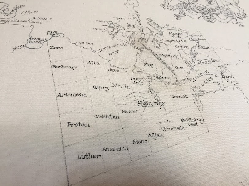
We usually think of Merlin as a legendary wizard featured in many historical and mythological books and movies alongside King Arthur and the Knights of the Round Table, but it was also the name of a former Township of Simcoe County in 1832.
Originally, the northern shore part of the township where Collingwood and Wasaga Beach are now, was called Java and the southern part dividing at Duntroon was Merlin. In the same year, after being surveyed first by Thomas Kelly and then by Charles Rankin, it was decided that the two small townships would amalgamate into one and be named Nottawasaga.
The name was derived from Algonquin or Iroquois words “Nahdoway” or “Nahdowa” and “Saga” or “Saghi,” which signifies “outlet of a river of the Iroquois.”
The land that was being used for Ojibwa hunting and gathering expeditions would soon have immigrants travelling from Scotland (Duntroon), Ireland (Fourth Concession/Fairgrounds Rd.), and Germany (near Batteau) in hopes of settling into a new and improved life.
In Merlin, Thomas Kelly writes that he found two beaver meadows, an old fort and two extinct volcanoes in the sedimentary rocks of the Niagara Escarpment, but he never finished the survey. Apparently his alcohol drinking became problematic in his work, so in 1833, Charles Rankin was sent to complete the survey. Was Thomas Kelly drunk when he noted these unusual and wondrous discoveries, or did he see some magic that others couldn’t? Nonetheless, the people came with their own stories and legends of their far away homeland and wrote of new tales of adventure of this beautiful and wild land of Upper Canada.
Today, the towns of Collingwood and Wasaga Beach are independent municipalities and Nottawasaga Township amalgamated with Sunnidale Township to form the municipality of Clearview in 1994.
There is so much history, beauty and yes, the magic of nature to be found hiking on the trails of the Niagara Escarpment, and who knows, maybe you’ll even run into a Wizard in the Land of Merlin.
Hikers can view Clearview Township from the top of the Niagara Escarpment via the Bruce Trail map #23, from the Petun Conservation Area, the Pretty River Valley Provincial Park and the Nottawasaga Lookout Provincial Nature Reserve.
Visit the Bruce Trail Conservancy web-site to order the 2020 Map and Trail Guide, or just individual maps. https://brucetrail.org/trail-sections/4 For scheduled group hikes, go to the Blue Mountain Bruce Trail Club website http://www.bmbtc.org/.
For more information about the information contained in this column, you can review the works of John Graves Simcoe via the Simcoe County Archives, and the history of Simcoe County by Andrew Hunter.
For historic maps of Nottawasaga Township, click here.


